
Sponsored By Wood County Park District
AS AN UNDERGRADUATE, I took a course called Philosophy of History— not to be confused with History of Philosophy. The semester can be easily summarized on a 3x5 card: Ancient nomadic people stumbled onto a fertile valley with a reliable water source. Decided to settle down and stay. Over time they prospered, grew soft and complacent. Their prosperity drew the attention of rugged hill people who came down and took it away from them. They in turn prospered. Lather, rinse, repeat.
The main focus of the course was on how this played out in the ancient Middle East. The implication was the pattern has been repeated all over the world, including in what is now the U.S. Perhaps I just wasn’t paying close attention to the professor and misinterpreted what he said. (I know. That sounds improbable, doesn’t it?) So, I will just insist that the theory may have applied there but not here in any way that is obvious to me.
That statement is based on our travels in the Southwest. There are signs of once prosperous civilizations all over the region. But ancient peoples in the New World seem to have prospered in unlikely places rather than fertile river valleys like the Nile or the Tigris-Euphrates. Furthermore, it is difficult to find a succession of different civilizations in the same locale. The ancients may have left a place, but there is little sign that others came to occupy the vacated space either by conquest or simple opportunism.
But this is supposed to be a travel column and I have drifted into areas well beyond my professional competence. So, here are some observations about places we think may be worthy of your attention. First, there are plenty of archaeological sites east of the Mississippi, but only real professionals are likely to recognize them. The building materials were basically trees and dirt. Structural wood rots and is eventually replaced by live trees and shrubs that grow up and take over the space. Archaeological evidence for ancient cultures exists in places like the Hopewell Mounds near Chillicothe and all along the Natchez Trace. Only the trained eyes of archaeologists wearing Indiana Jones hats can recognize and interpret evidence that mere mortals overlook.
Not so in the desert Southwest where the primary building material was rock. There is evidence of habitation there going back 13,000 years or so. You don’t have to be Indiana Jones to recognize that the Ancestral Puebloans of our Southwest were pretty good architects and engineers whose homes and ceremonial spaces survive to this day. In various states of preservation, obviously. Often there is nothing left but the foundation or a low wall. Elsewhere almost entire buildings are intact. Roofs collapse because they are supported by wooden beams covered over with brush and adobe.
We visited Bandelier National Monument in Northern New Mexico in response to Shirley’s Rule: As long as we are in the neighborhood anyway... Some of our most memorable travel experiences fit in that category. The primary objective on that trip was to fish the trout streams in the mountains and walk around historic Santa Fe. From there, Bandelier was only a modest detour on our way up to Pagosa Springs, CO. Chaco Canyon is another site along the way, but the road back in there was closed. Bandelier is an Ancestral Puebloan site in the narrow canyon of Frijoles Creek, a small tributary of the upper Rio Grande. It is just a short hike through the tall Ponderosa pines along the narrow stream to a waterfall at the confluence.
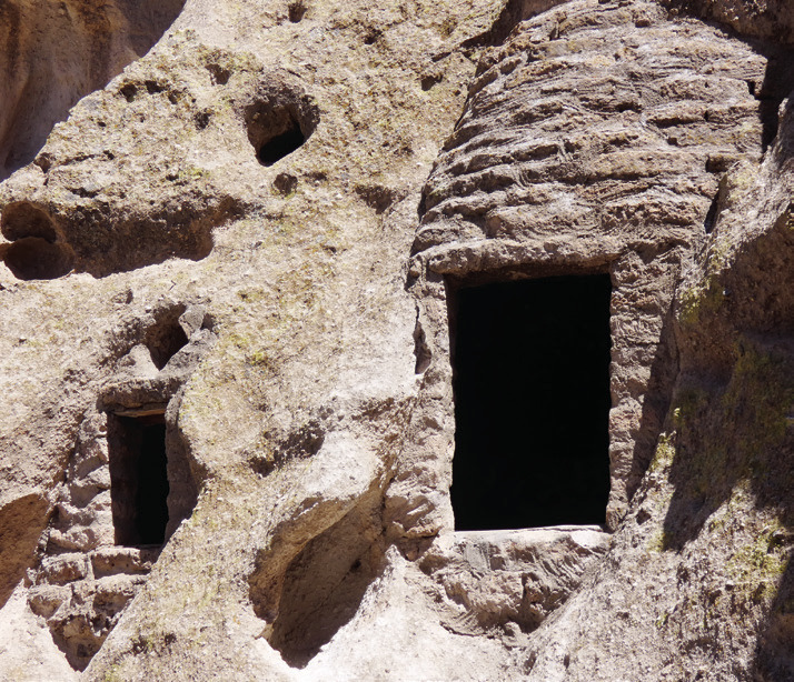
The structures at Bandelier are almost entirely ruins, but you can clearly see the evolution of the settlement from underground pit houses and ceremonial kivas lined with stone. Then came adobe and much more substantial dwellings at the base of a sheer cliff. Frijoles Canyon had just about everything people could want per the Philosophy of History. There was plenty of water, wood for fires and construction purposes, and shelter from the winter winds. The cliffs themselves were a further benefit because the rock, despite being called Tuff, is actually soft and relatively easy to cut and shape.
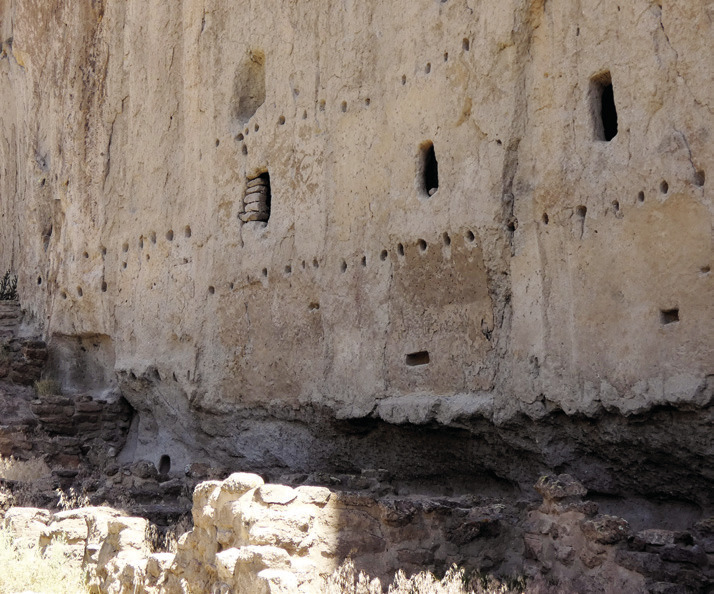
The face of the cliff provided the back wall for an extensive pueblo. Think of the advantages of a home that only required the construction of three walls. Maybe not even that. The village was like a condominium in which you shared a common wall with your neighbors. Hundreds of round holes cut into the rock clearly indicate where roof beams were placed and that the condos were at least two stories high. In the cliff face are dozens of small natural caves that were artificially expanded as “cavates” to serve as natural closets and storage rooms. The openings to the cavates were often squared up with cut stone so that they could be sealed against the weather and pesky vermin that might want to eat your winter supply of food. Today their chief function seems to be as places for children to poke their heads through for photos.
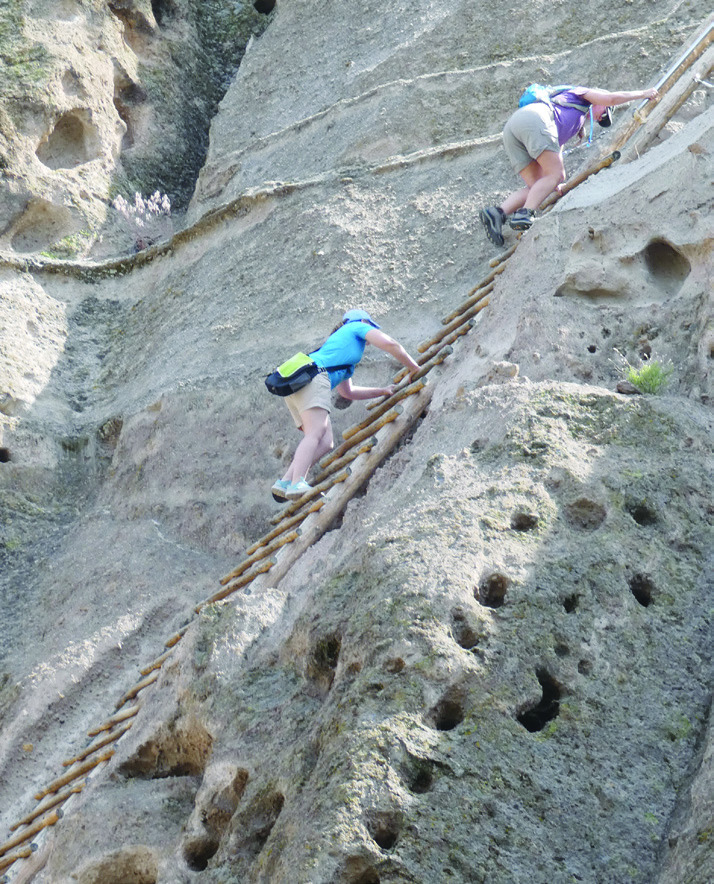
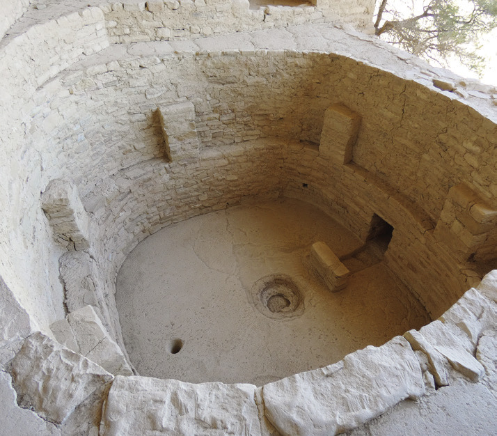
For us, the highlight of Bandelier was climbing the ladder to Alcove House. The sign at the start has some good advice: “Notice: A 140 ft. vertical ascent. Those with health problems or fear of heights should not attempt the climb.” Alcove House is in a shallow cave where a ceremonial kiva was built. Kivas are typically 6 to 10 feet floor to ceiling. Picture climbing a vertical cliff to the height of a 10-story building, then digging a pit in the rock floor of the cave and lining it with shaped stones, then hauling up timbers for roof beams and thatch and adobe to make the roof. Today’s weekend handymen have no idea what a real Honey-Do List looks like.
Evidently, the Ancestral Puebloans abandoned the site during the Little Ice Age (mid-1600s to mid-1800s) when temperatures began to rise again. Their descendants in the Taos, Acoma, and Zuni tribes still live in the area, but there is no evidence of occupation after the departure. If they were driven out by more rugged people, one would expect the conquerors to have stayed. Perhaps their leaders just decided that it was time to move on for some ancient political or religious reason.
From Bandelier we continued up to Pagosa Springs and then west on Rt. 160 to stop for a day at Chimney Rock. Now, there are more than 50 places called Chimney Rock in the U.S. Probably the most significant one we had visited was a major landmark on the Oregon Trail. Crossing the prairie, every mile looks pretty much the same, so it is helpful to have a guidepost now and again. We had driven right past Colorado’s version of Chimney Rock several times under the false impression that it is just another such mile marker.
It is actually a noteworthy ancient Indian astrophysical site. There are well-known places all over the world associated with observatories. Sky watchers thousands of years ago were intensely focused on determining the precise dates of solstices and equinoxes as the basis for scheduling the planting of crops and the observance of secular and religious ceremonies. Consider, for example, that Christmas is always Dec. 25 but Easter varies from year to year. That’s because Easter is the first Sunday after the first full moon following the vernal equinox. This year, Easter is about as late as it gets.
I mention this because Chimney Rock is a lunar observatory rather than the more usual solar variety. The dates of solstices and equinoxes are annual events that are established when the first rays of the rising sun pass through a narrow opening in stone and illuminate a precise point in a dark space. The critical event at Chimney Rock is the Lunar Standstill that happens only once every 18.6 years. Consider the skill and patience required to figure that out. Then consider what it took to identify the exact place where the standstill could be observed.
As you know from personal observation, the sun appears to rise in slightly different locations depending on the season. The place where the moon rises and sets varies even more as it shifts along the horizon from its farthest northeast position to the farthest southeast. A major lunar standstill is when it reaches either extreme position. The full explanation is considerably more complex than that, which causes me to admire ancient astronomers even more.
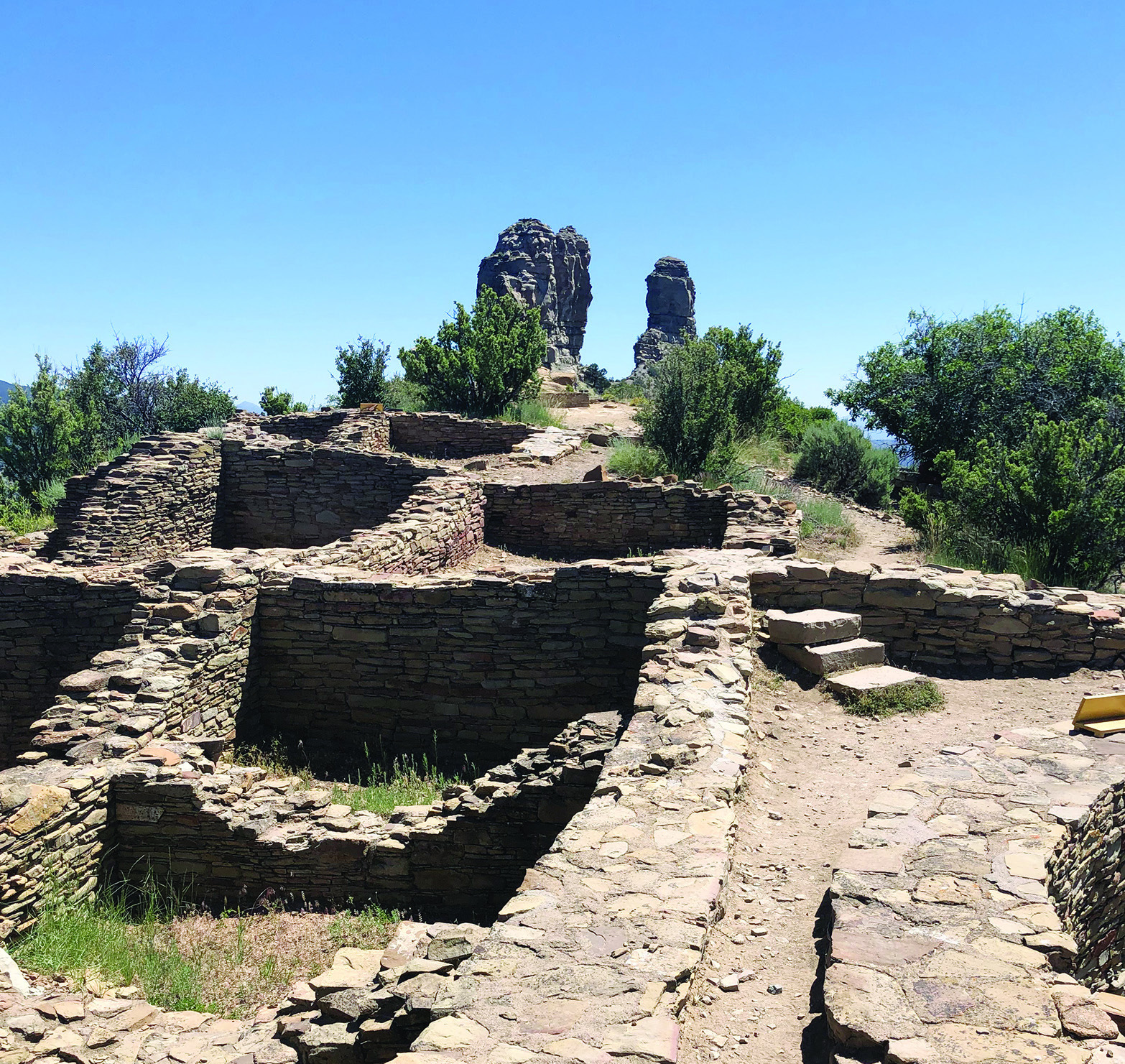
At Chimney Rock, the standstill is marked by moon rise directly between it and its neighboring Companion Rock. These two spires are at the end of a very narrow ridge on which the Ancestral Puebloans built a small village. Plenty of rocks for building material up there, but roof beams had to be transported from a forest you can see way over on the western horizon. Well, they didn’t actually have to get their timbers from that far off. There are trees right at the base of the ridge, but apparently they were not appropriate, perhaps for some religious reason. The Great House Pueblo Trail to the ruins on the ridge top is a little less than a mile round trip, but it crosses steep and uneven terrain with precipitous drop-offs. We were glad we were only carrying water bottles rather than trees and boulders. You may have heard that prosperity makes you soft.
If this information stirs your curiosity, note that 2025 is a lunar standstill year. Check the park website for details. Or plan ahead for 2043.
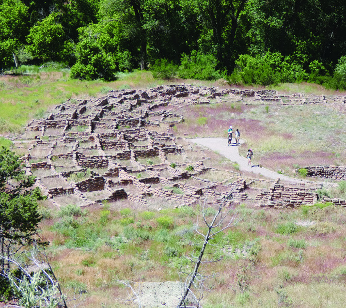
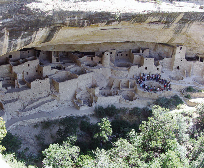
Ninety miles farther west is Mesa Verde, the preeminent archaeological sight in the country. The name means Green Table because of its flat top crowned by trees and other vegetation. The top, at an elevation of about 8,500 feet, is not actually flat though it appears so way down at the base. The walls of the mesa rise almost straight up, so the top was not explored by European Americans until 1888 when rancher Richard Wetherill went up there looking for stray cattle. Local Indians knew what was up there but had little motivation to visit or even talk about it. Even in a motor vehicle, the steep, winding climb is not to be undertaken lightly. Wetherill was amazed at what he saw—an ancient Indian city of stone tucked back under an overhanging ledge. It is aptly named Cliff Palace because it is an architectural and archaeological wonder.
Wetherill and his family returned to explore and collect artifacts, some of which they sold to museums. This attracted the attention of “pot hunters” and looters which, in turn, motivated President Theodore Roosevelt to create Mesa Verde National Park to protect the site.
The mesa was occupied for more than 700 years, and there are more than 600 cliff dwellings. There are ruins of many more, long hidden by trees and shrubs, that continue to be discovered today up on the top of the table. The Puebloans grew corn, beans, squash, and turkeys up there until they suddenly left about 800 years ago. Initially, it was speculated that the population sheltered from more aggressive neighbors by building in inaccessible places. Today there are ladders for the convenience of visitors, but hand and toeholds carved into the rock indicate Cliff Palace was not easy to reach. Yet an amazing array of residential and ceremonial spaces were constructed there. There are natural springs in the cliff space, but this does not qualify it as a fertile river valley.
When Shirley and I visited for the first time, there was an admission test next to the ticket counter. It was a plywood tunnel about two and a half feet high and wide, about 10 feet long. We had to get down on our hands and knees and demonstrate that we were capable of crawling through there. A portion of the tour went through a rock tunnel of that size. People with knee or hip problems could find crawling through a rough, twisting stone tunnel in the dark a challenge. Also, those prone to claustrophobia might want to consider that. So should people grown corpulent and sedentary over the years. Just saying.
In addition, we were advised that there were narrow ledges, tall ladders, and steep places on the cliff face with chains to hold on to. Then there was the matter that an elevation of about 8,500 could challenge those with heart or breathing issues or who have not yet adjusted to the thinner air.
On subsequent visits, we found that the test tunnel had been removed. In my opinion this was a mistake, but nobody asked my opinion. Finally, the tour may be stressful for those nervous about heights. One woman on our tour was appalled when confronted with the climb. I can quote her exact words: “I thought they were kidding!” Once you start, there is no turning back because of narrow ledges with no room to pass the people coming behind you. The good news is, even if you are not quite up to the tour, there are vantage points for viewing and additional sites on the mesa where these issues do not apply.
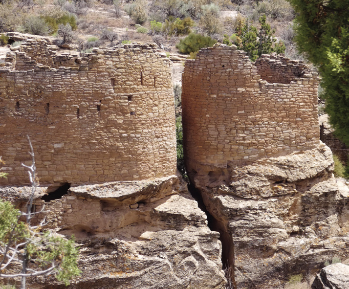
There are also numerous other Ancestral Puebloan sites all over the Southwest. I have mentioned Chaco Canyon. On our way to the South Rim of the Grand Canyon, we visited the ruins at Petrified Forest and Painted Desert. On the North Rim there is a site at Walhalla. Just 12 miles north of Mesa Verde is Canyon of the Ancients with 8,500 identified structures. This is out of an estimated 30,000 that archaeologists expect to eventually find there.
There are treasures of all kinds to seek out in the Southwest. Put on your Indiana Jones hat and go take a walk in a park. Or several of them.
You might want to see more of his stories and photos at AnotherWalkinthePark.blogspot.com. ✲