
YOU MAY REMEMBER HEADING WEST around Chicago when it was a significant challenge for a couple decades when road construction on I-80 reduced five lanes of traffic down to one. An option we adopted traveling to Glacier NP or Yellowstone was to go through the Upper Peninsula. It might seem like a long detour, but there is plenty so see and do along the way through the Dakotas, Montana, and Wyoming.
This came to mind recently when I was talking with a neighbor who was not aware that the UP is part of Michigan. (Really? Really!) He knew that the map of the state is made by looking at the palm of your right hand. Unfortunately, there is no way to hold your left hand to form the rest of the state.
So, other than to avoid Chicago, why would you go to the UP? And why is the UP part of the state that looks like your hand? The beginning of the answer is the Toledo War of 1836. There had been a dispute about the proper boundary between Ohio and Michigan that was settled by drawing the line far enough north to put Toledo in Ohio. Part of the reason for that decision was that Ohio had been a state since 1803 and had more political clout. In exchange, Michigan was granted statehood and the UP. Snarky Michiganders are prone to claiming that they got the better part of the deal. I didn’t bother going into that Lost Peninsula thing with our neighbor. Even good neighbors and patient readers won’t tolerate that much errant pedantry. Upper Peninsula, Lost Peninsula. What’s the difference?
Hardcore Yoopers might be able to afford to winter in Florida, but they prefer to stay up there when it becomes a white wonderland. Sensible people think it only looks wonderful in photos. Yoopers who are not genetically engineered to love the cold join their sensible friends at the club especially for them in The Villages. There are so many expatriates down there that Florida even has a source for pasties, the Yoopers’ national dish, at the Old Miners Pasty Shop. A pasty, by the way, is a hardy, folded over, hand-held meat pie favored by Cornish copper miners in the late 1800s. (They are similar in appearance but not in taste to calzones and empanadas.) Just as real Yoopers scoff at softies who go to Florida, they are also prone to denigrating “gourmet” pasties like the chicken cordon bleu or vegan variations that are foisted on the unsuspecting.
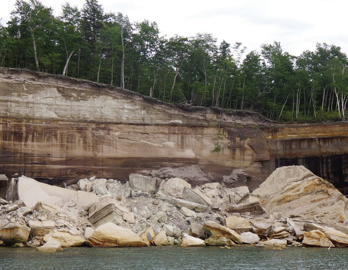
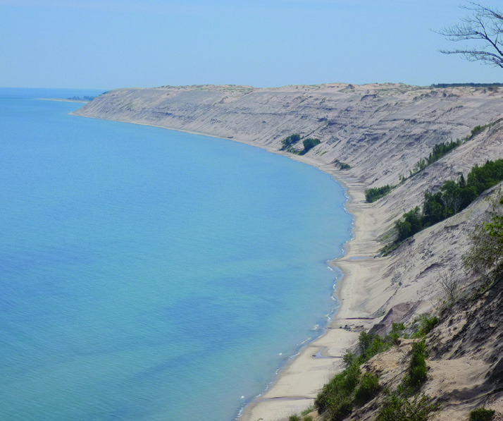
But I digress. There are hundreds of other reasons to visit the UP besides trying to avoid Chicago. There are 150 waterfalls, for example. Maybe 300. Even the state of Michigan is not sure of the count because many are hidden way back in the seemingly endless forest. Fortunately, some are easy to reach in Pictured Rocks National Lakeshore. The park occupies about 40 miles of coastline and takes its name from the colorful sandstone cliffs that have been eroded by the winds and waves of Lake Superior. Plus, of course, the freeze and thaw of UP winters. The “pictures” are created by the streaks and stains of minerals washed down cliff faces: iron accounts for the reds and oranges; blue and green come from copper; black and brown from manganese; white is limonite or calcium.
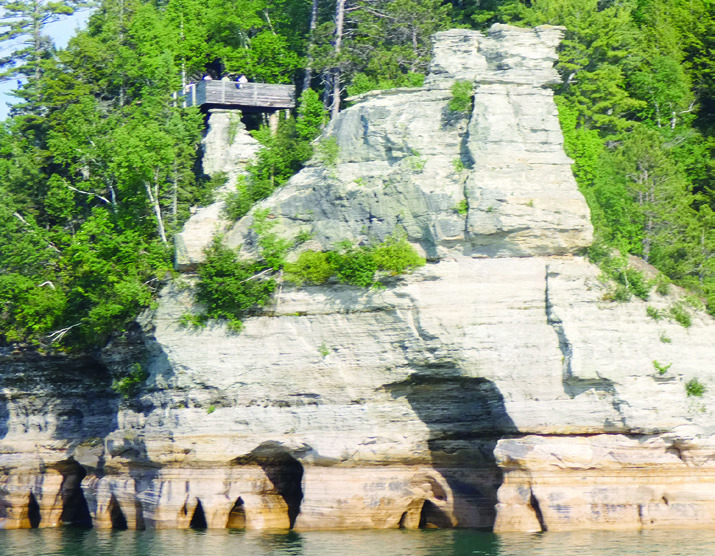
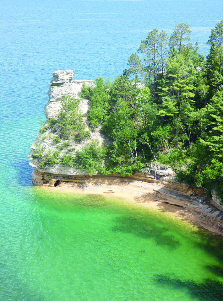
There are very few impressive cliff-viewing sites on land because you are standing on what you want to look at. Miners Castle, about five miles east of Munising, has two viewing platforms, the lower of which requires descending stairs or a steep trail that switchbacks for about 1,000 feet. Even there, the view cannot begin to compete with that available from the water.
Which is why Shirley and I endorse Pictured Rocks Cruises and further advocate for booking as soon as you think you might be going. They book up months in advance and sell out regularly. We made reservations for the Spray Falls tour. It goes to the same destinations as the Classic Cruise plus an additional 10 miles to the 70-foot falls spilling over the cliff into the lake. Even though it is the most distant destination of the cruises, it is made in the fastest boat, so it takes about two hours instead of three. The lake can be cold, windy, and rainy no matter the time of year so it’s a good idea to go prepared. Most people prefer the views from the upper deck. If the weather turns suddenly unpleasant, the covered lower deck cannot accommodate everyone who might desire shelter. But you are not a wuss.
I booked the 5:00 tour because I wanted late afternoon sun on the cliffs for better photos. Naturally, the beautiful, sunny afternoon clouded over about 4:30. It was OK, though, because it started to clear again about 15 minutes before the end of the cruise. With that said, it was still a lovely experience. We have been to literally hundreds of waterfalls and colorful rock formations all over the country, but Pictured Rocks from the lake vantage point is special.
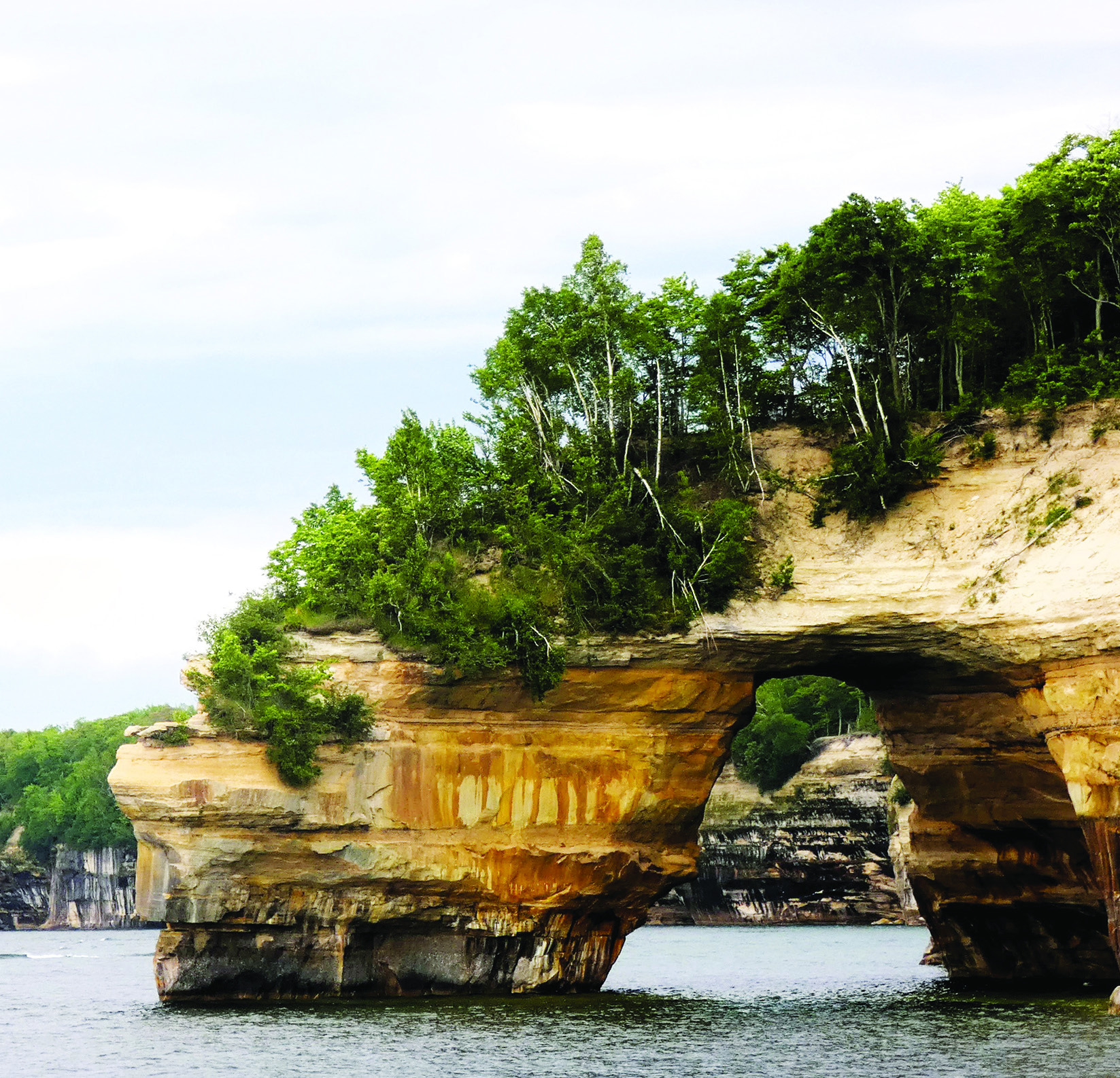
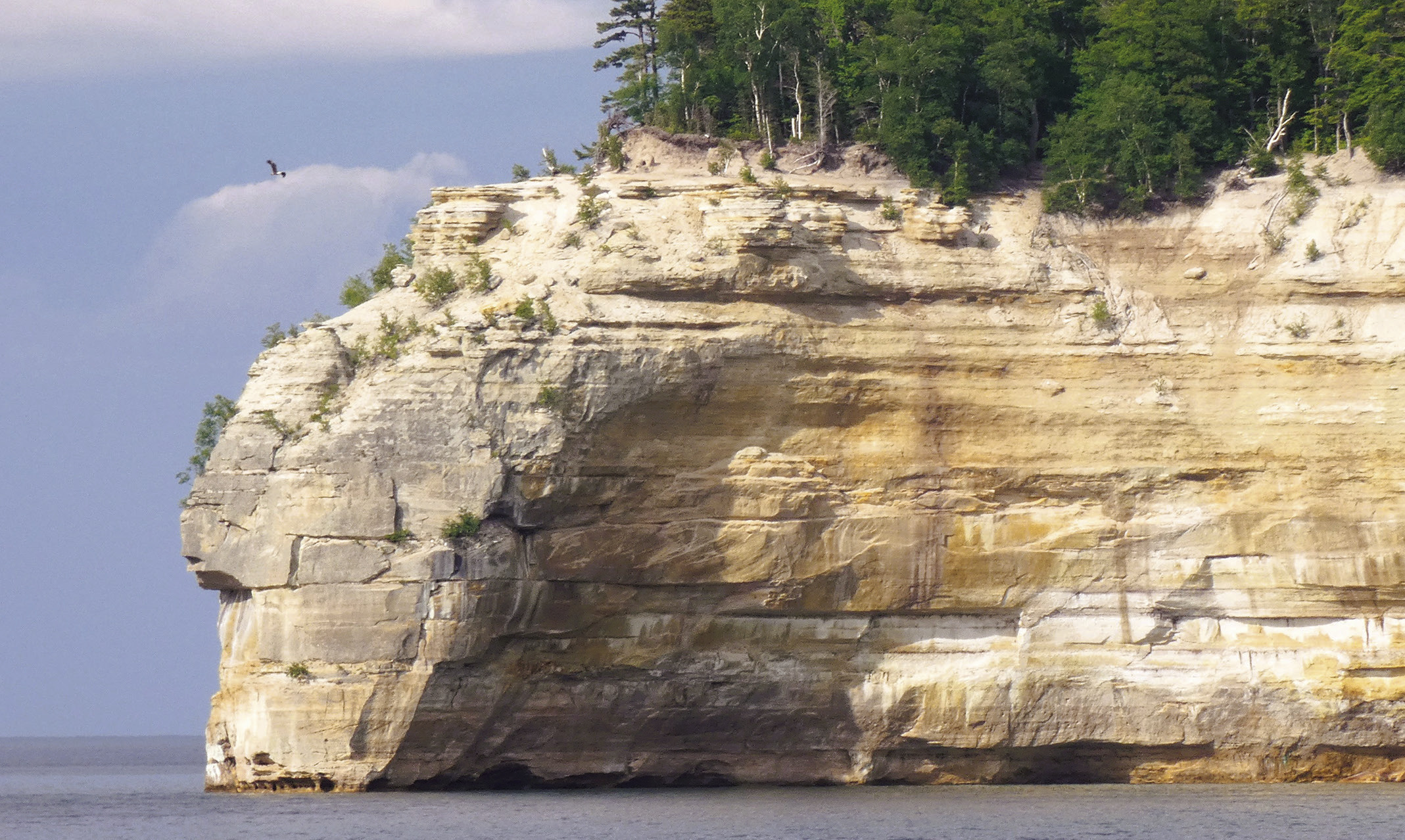
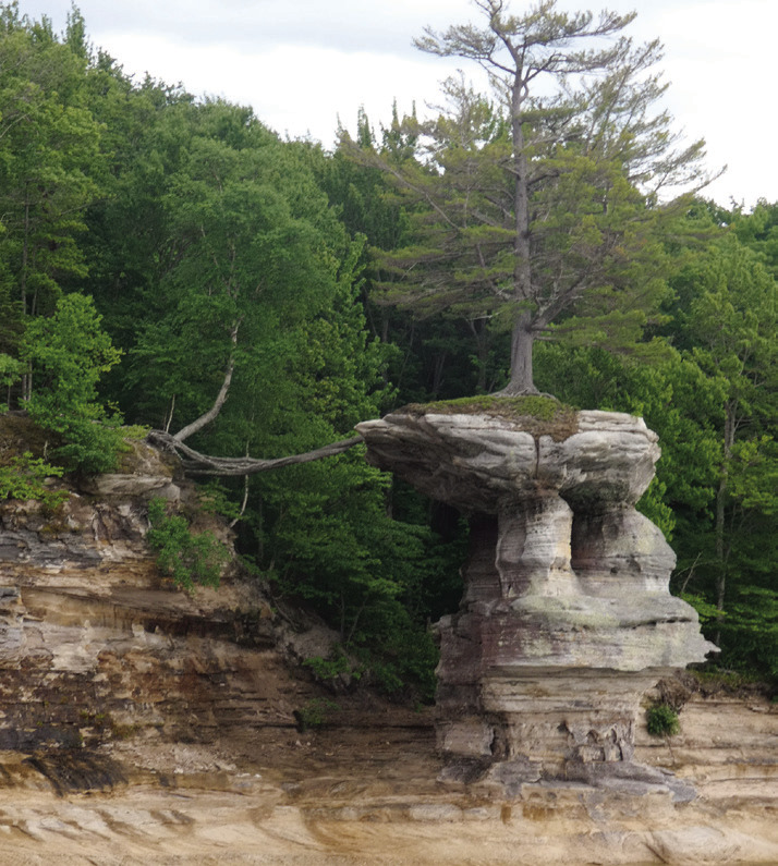
After the first pause at Miners Castle, where we could see what we had been missing, we continued to a series of attractions that featured what wind, waves, ice, and mineral seepage have done to enhance the appearance of the rocky shore. In places, the cliff face reaches a height of 200 feet with dark pines punctuated by the white trunks of birches. As surface water seeps down through layers of sedimentary rock, it picks up minerals that flow horizontally until it finds a narrow crevice through which to emerge. The base of the cliff is decorated by fingers of white calcium or limonite that look like icicles. There are also hundreds of sea caves of various sizes. Occasionally, the freeze-thaw cycle has sliced off huge pieces of the rock face. There are also pillars of rock that are beginning to separate from the cliff. Soon, in geologic terms at least, they will also tumble into the water. One of these oddly contorted pillars had a tree growing on top that was still clinging to the mainland by a few roots. The virtually bare place it occupies cannot sustain it. Reminded me of someone standing with one foot in a rocking boat and another on the dock. Eventually, something has to give.
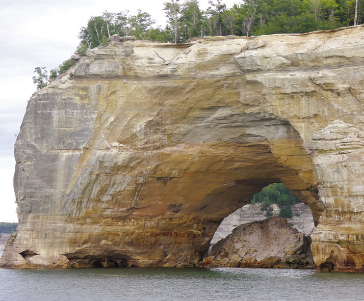
At two promontories, Grand Portal and Lovers Leap, there are arches formed when water wore its way through. Grand Portal used to be popular with boaters and kayakers because they could travel right through. The Portal has been closed, though, by the collapse of the roof. Still quite scenic.
The next pause was at one of the 87 Bridal Veil Falls in the US. (People who name scenic wonders tend to draw on a short range of cliches.) In this case, you could argue that the thin veil of water, narrow at the top and broadening out as it flows down the cliff face to lake level, might actually justify the name. The cliff is not completely vertical there, so, after the first 25 feet or so, water cascades at a steep angle over layers of yellow, orange, and rust.
Spray Falls actually spills straight down from a sheer cliff and marks the eastern terminus of the cruise where the boat turns around. This gives the folks on the port side a better chance to see what those on the starboard side had been oohing and aahing about. On the return half of the cruise, the captain also took us closer to shore and actually into it. That is, he carefully maneuvered into an alcove that was barely wider than the boat. He was just showing off.
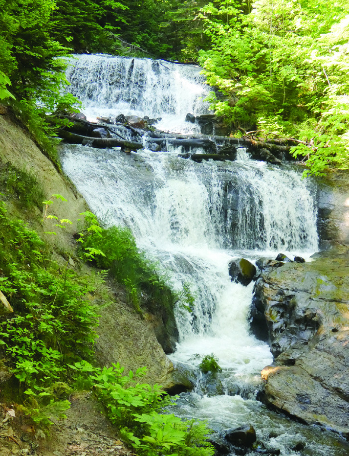
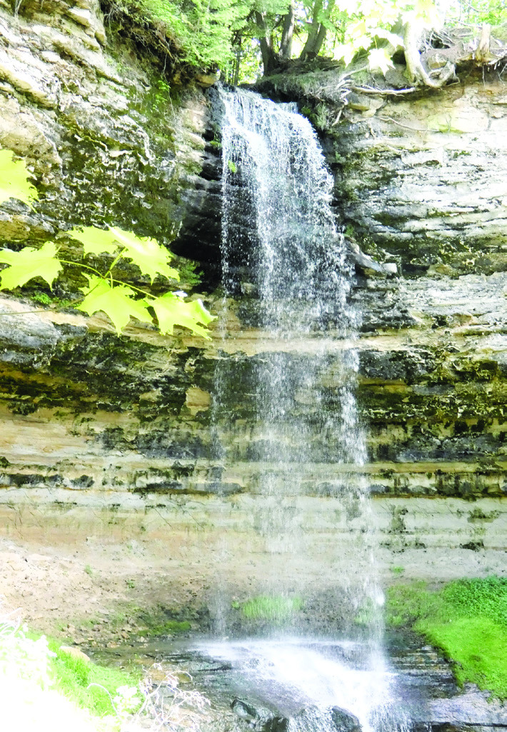
The park has other attractions that make it popular. Sable Falls is near Grand Marais at the east end of the park. We stopped at the visitor center to talk with the host about the trail out there. The sign said 1.2 miles, and we were assured the walk was mostly easy through a forest of hardwoods and pines with trilliums and little bluets. Plus, there is the option of a short detour to the long stretch of dunes. Sable Falls is a lovely cascade that was definitely worth the walk. Even so, the nice host lady might have mentioned an alternative. Continue down the road to a parking area at the head of the falls followed by a descent of 168 wooden stairs to a viewing area at the base of the falls. There comes a time when knee surgery, hip replacement, and bypass surgery make you grateful for this kind of information.
On the way back, we made that detour to the long stretch of dunes. There were wild roses along the way and a rather large garter snake snoozing in a sunny place right in the trail. But, like the picturesque rock formations, you don’t get an adequate view of the dunes while standing on them. Fortunately, there are other places where an arc in the coastline provides an impressive view.
We also took the walk out to Chapel Falls, described in the park literature as the most beautiful. While we were in Munising, we took the short, easy walk to fifty-foot Munising Falls found right behind the Visitor Center. There are viewing platforms on either side. Both of these falls are worthy of your attention.
From the UP we continued across Wisconsin and Minnesota to Theodore Roosevelt National Park in North Dakota on our way to Yellowstone and the Tetons. All are, likewise, worthy of your attention and will be covered in future installments. Individually and collectively, they are just a walk in the park.
You might want to see more of his stories and photos at AnotherWalkinthePark.blogspot.com. ✲