
Bryce


I WORKED WITH A FELLOW who had spent part of his career in Utah. Said he was really happy to be back in the Midwest where everything is green. “Utah is nothing but rocks,” he said.
Yes, I thought, but that’s like saying a beach is nothing but sand or Giant Sequoias are nothing but trees. Utah is desert country where geology is king. There is a reason the state is home to five national parks with numerous other impressive places in between. Utah may be nothing but rocks, but they are magnificent rocks and you need not be a geologist to see that they are not all just the same old kind of rocks. Each national park, therefore, has its own distinctive kind of beauty.
When you plan to visit Utah, give some consideration to the season. Utah can get a little warm in the summer. It is also high desert, so there can be a nip in the early morning air, even in August, depending on the elevation. Spring and fall tend to be mild.
There was a time when spring and fall also meant the parks were less crowded. We no longer live in those times. Part of the reason is demographic. As Baby Boomers started retiring en masse, the natural appeal of the national parks attracted them by the millions. COVID restrictions created a lot of pent-up demand for travel and outdoor activities. For RVers, there is now the added challenge of dealing with campgrounds that require reservations—often six months or more in advance—where once you might have just pulled in and selected a site.
There is now also the issue of dealing with the price of fuel. Still, some RV owners are prosperous enough to not be dissuaded by fuel prices. If you paid a quarter million for your rig, you really shouldn’t get all worked up by a few extra dollars to run it. But, then, we all have different definitions of “a few extra dollars,” and there are obvious differences between the cost of driving 200 miles and 2,000.
If you have neither ample leisure time nor an RV for your Utah adventure, you might consider flying into Las Vegas. Air fares to Vegas are often less expensive than other destinations. They’ll find other ways to separate you from your money. Rental cars, and even RVs, are readily available there.
If your ambition is to visit the five national parks in Utah, it is easy to devise a circular route so you can hit all of them with no backtracking and include other attractions along the way.
Arches
Visitors appreciate the chance to see some of the more accessible of the 2,000 known natural arches in the park. (Most are in the rather inhospitable back country that only the young, fit, and foolish are allowed to enter.) Arches differ from natural bridges in that they are formed by freeze-thaw weathering rather than flowing water that bores a hole through a cliff wall.
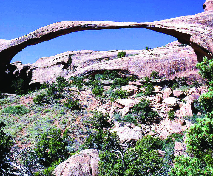
There are convenient parking areas within a short walk of most of the arches you have seen on the National Geographic channel. At minimum, be sure to stop at Landscape, the longest span in North America at 306 feet and only six feet thick at its narrowest point. The Windows are side-by-side arches through which you can view Turret Arch, connected to them by a short trail. The iconic Delicate Arch is depicted on Utah license plates and featured prominently in tourist promotions. Delicate is a free-standing, horseshoe-shaped arch attached to the ground at either end rather than spanning the space between cliffs. It seems to me that Landscape looks much more delicate than Delicate, but nobody would put me in charge of naming landmarks.
We also highly recommend the loop trail around Balanced Rock. There are thousands of balanced rocks in the Southwest that, like the arches, are created by the weathering away of a layer of relatively soft rock beneath layers of harder rock. Balanced Rock is noteworthy for its impressive size at 128 feet and for what appears to be an exceptionally precarious balance. By taking the trail around and underneath, you will find that it looks surprisingly different when you change your viewpoint. It also can be a little unnerving to stand directly beneath it. Rangers assure us that it is not actually balanced but firmly attached to its pedestal. Sure, it is.
Canyonlands
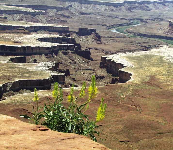
Just across Rt. 191 from Arches is Canyonlands NP. There is an overlook a few thousand feet above the confluence of the Green River and the Colorado. Green is not just a name. The river really is that color until it blends with the muddy brown of the Colorado. Far, far below, you may be able to make out some Jeeps switchbacking their way on a narrow gravel road with sheer drop-offs. This is rugged country that attracts adventurers of all sorts.
Most visitors, though, seem content to stand on the canyon rim, gawk at the awesomeness for seven or eight minutes, then continue to Moab where the Jeep commercials are filmed and the motels, B&Bs, and lodges all have air-conditioning. The commercial RV campgrounds have hookups, so you can run your AC if you need to.
On one visit, Shirley and I were fortunate to be at Canyonlands when the full moon was rising behind the far rim. Trust me, unless you have been someplace far from urban lights, you have never really seen the full moon. Or stars as big as quarters. The canyon itself is even more romantically impressive by moonlight.
In the southwest corner of Utah is one of those places that can instantly convince you it is the most wonderful, inspiring place you have ever been—even if the attractions are nothing but rocks. Sheer cliffs of red and white Navajo sandstone rise straight up for 3,000 feet or so. Unlike Canyonlands, where the view is from the top down, at Zion you are more likely to be looking from the bottom up. Mormon pioneers saw theses grand ramparts as the natural temples of God, so they gave them names that suit their Biblical proportions: The Temple of Sinawava, The Watchman, The Three Patriarchs (Abraham, Isaac, Jacob), West Temple, Altar of Sacrifice, Angel’s Landing.
In addition to the three national park campgrounds, there are commercial campgrounds with hookups as well as motels and B&Bs in Springdale. Alternatives are good because the park fills up virtually every night between mid-March and the end of November. Shirley and I were there one September when I foolishly thought that, because it was after Labor Day, all the families with kids had taken them back to school. Which may have been true, but I hadn’t accounted for the hordes of other retirees who shared my assumption.
Our favorite Zion trails are up to a plateau overlooking the canyon at Watchman, a climb to the Emerald Pools, along a narrow cliff ledge to Hidden Canyon, and the Gateway to the Narrows. The “trail” at the Narrows is the bed of the Virgin River with walls rising directly from the water on either side. Once you get past the rocky stretch at the beginning, the “trail” is sandy and easy wading. You can even rent boots in Springdale. They won’t keep you dry, but they will prevent ruining your personal footwear.
About an hour and a half northeast of Zion is Bryce Canyon where the rocks are totally different. At Bryce, the orange creamsicle colored rocks are soft and crumble away easily in the constant freeze-thaw of the high desert. The mudstone, sandstone, and limestone were formed at sea level but have been geologically uplifted to more than 9,000 feet. There are many more of those balanced rocks I mentioned earlier and, because they are softer rock, they have eroded into strange shapes called “hoodoos.” Be on the lookout for Thor’s Hammer and Queen Victoria.
The 18-mile park road runs along the rim of the canyon out to Rainbow Point where there is a grove of bristlecone pines about 1,800 years old. Near the park entrance is a short extension road out to Fairyland Point. Save breakfast for later and go in early morning if you want to beat the crowds and get the benefit of dramatic, low-angle golden light on the canyon. Which, by the way, is technically not a canyon but an open-ended amphitheater. But let us not be overly pedantic. The usual level of pedantry should be sufficient.
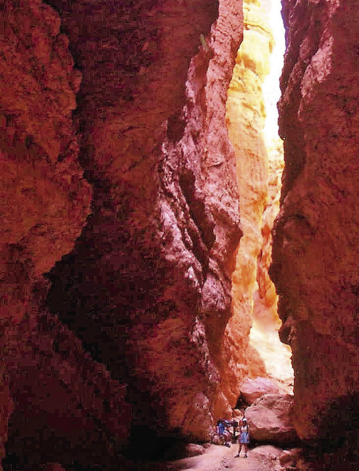
Behind the park lodge is an easy, paved portion of the Rim Trail between Sunrise and Sunset Points. You might also take the trail down steep switchbacks and through a very narrow passage called Wall Street and a hole in the wall called the Fat Lady Squeeze. (Call it something else if you wish to avoid offense.) You can then connect with the Under- the-Rim Trail for a loop that will take you back up to either one of those Points. Appropriate footwear is desirable both because the descent and ascent are steep and because the crumbly rock can make it feel like you are walking on ball bearings. We have seen people in flip-flops down there, but you are undoubtedly not that foolish.
If you are not a hiker, there are pullouts all along the road where you will want to fill up your phone camera and all your cloud storage.
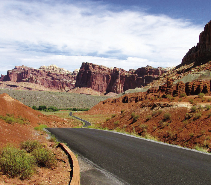
again, the focus is on geology, specifically the Waterpocket Fold. This is a big gosh-awful deal to those who, unlike my former colleague, are impressed by rocks. Basically, the Fold is a 100-mile-long crack and uplift of the earth’s crust in which layers of rock on the west side were raised 7,000 feet above the east. All those layers of colorful rock are tilted back at an angle, so they are exposed to view as if you had riffled the pages of a book.
The park name is based on the white Navajo sandstone formations that early visitors thought resembled the domes of capitols. “Reef” is a reference to the barriers encountered at sea. Other park place names actually make sense without having them explained to you. Fruita is the remains of a pioneer Mormon orchard and farm along the Fremont River. The heirloom varieties of apple, peach, cherry, nectarine, and apricot trees still bear fruit that visitors are allowed to collect for personal consumption. Shirley and I like the campground there. Not only is it shady in the warm months, but, more importantly, it is the only campground. It is also a base for easy access to Scenic Drive—a totally accurate and understandable name. The Drive is eight miles of paved road that gives way to dirt and gravel suitable only for high-clearance, four-wheel-drive vehicles.
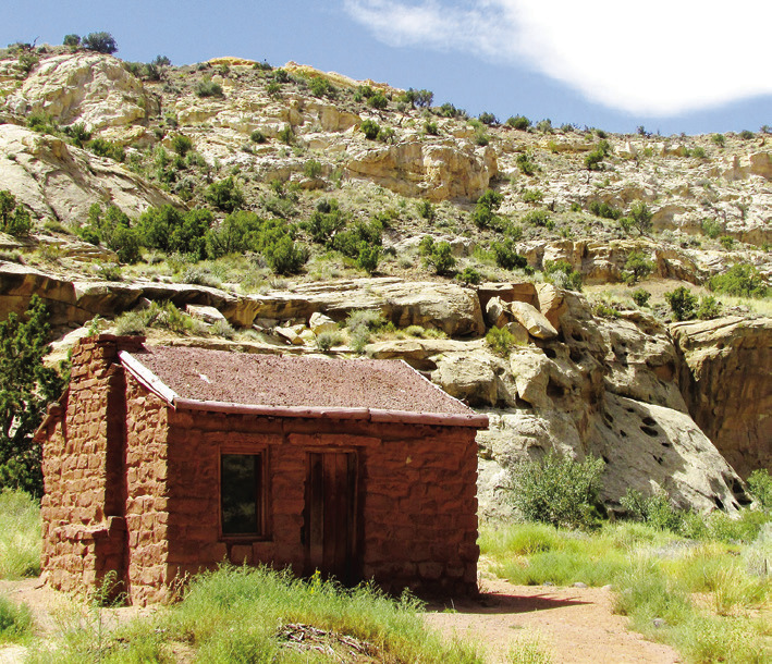
Rt. 24 runs east-west through the park with more trailheads and numerous places to stop to look at rocks and other stuff. The 1882 Elijah Behunin Cabin, for example, was the 13 x 16 ft. home built of rocks for a family of 10. The parents and two youngest children slept inside. The other six kids slept out. Evidently Elijah couldn’t find enough rocks to build a bigger house.
On your way from one park to the next, stop at other Utah attractions as well. The quality of the scenery does not diminish just because it is not included in a national park. There are also other bonuses. Monument Valley straddles the state line with AZ, but the entrance is in UT. Likewise, the Grand Canyon is in AZ, but we prefer the North Rim that is accessed from Jacob Lake, UT. Virtually any place you choose in Utah will be just a walk in the park.
LeMoyne Mercer is the travel editor for Healthy Living News. If you are contemplating a trip, you might want to see pictures and information on numerous destinations at AnotherWalkInThePark.blogspot.com. ✲
