
Sponsored by Wood County Park District
IN THE MIDDLE OF JUNE, Shirley and I took our RV out of storage and brought it home to load up the refrigerator and the pantry. Our neighbor Dan came over with several questions: when are you leaving, where you going, how long does it take to get there? They may seem like simple, straightforward questions, but we are not simple, straightforward people. Or, at least one of us is not.
The “When are you leaving?” part was pretty easy, but when you tell somebody you are going to Colorado, what does that mean? Our first family trip to Colorado in 1980 had a definite place in mind—Rocky Mountains National Park. Before retirement, all our trips were heavily influenced by the amount of vacation time we had accrued, so we chose a specific primary destination and opted for the travel efficiency of the Interstates.
In retirement, we rarely go to a single, specific place. Or even two or three specific places. The trip itself is the destination. Dan was just being neighborly and only interested in the Readers Digest version of the trip. So, I told him we were doing a loop through the southern half of the state.
Our preferred route in recent years is to Lexington, KY, then west to Land Between the Lakes, through the Ozarks of southern Missouri, and out onto the plains of Kansas to Dodge City where Wyatt Earp and Doc Holliday made their reputations and the Longbranch Saloon still stands. On the plains of eastern Colorado is Bent’s Old Fort. Usually we continue through Walsenburg and Great Sand Dunes National Park on Rt. 160. A couple of times we dipped down to Santa Fe, NM and over to see the ancient Indian cliff dwellings at Bandelier National Monument. From there, we have continued to the even more impressive
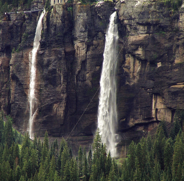
dwellings at Mesa Verde and completed our archaeological tour at Hovenweep and Canyons of the Ancients National Monuments on our way to the picturesque ski town of Telluride set back in a box canyon with double waterfalls.
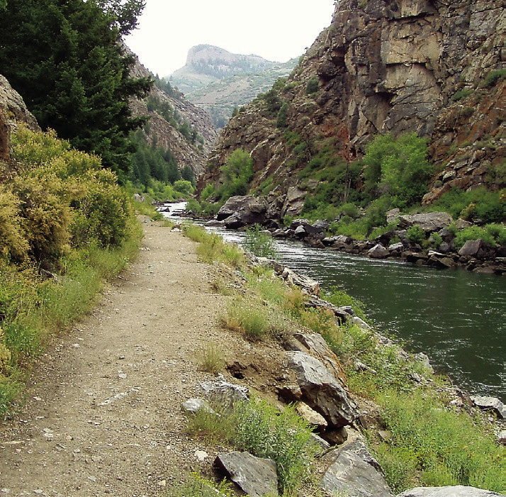
The more usual route is north on Rt. 550 from Durango. “The Million Dollar Highway” is so designated for the views rather than the construction cost. (These days you can’t build even a simple roundabout for a million dollars.) The highway is paralleled by the Durango & Silverton Narrow Gauge Railroad, on which a steam engine takes passengers to stunning back-country scenery. The train ride is a real treat, but you get almost exactly the same view from the highway as it winds along the Animas River. There are numerous places to stop along the 100 miles to Montrose. You could drive that in about two-and-a-half hours. But you shouldn’t.
At Montrose, we turn east on Rt. 50 for about ten miles to reach the entrance road to the south rim of Black Canyon of the Gunnison National Park. The park entrance is where you begin the long climb to the canyon rim. When Shirley and I were novice travelers in the West, we assumed that the great canyons were below ground level. After all, if the Grand Canyon is a mile deep, logically you would look way down into it. Which is true. But only after you climb a mile up to the rim. Like the rim of Grand Canyon, the Black Canyon is at an elevation of about 8,000 feet.
The Black Canyon was cut by the scouring action of the Gunnison River as it roars through the depths. The Gunnison descends farther in the 48 miles through the national park than the Mississippi does in its entire 1,500 miles between Minnesota and the Gulf of Mexico. Within the park boundaries, the Gunnison drops almost 100 feet per mile, and in one stretch it drops 480 feet in two miles. Fast water, laden with grit and rocky debris, continues to carve the canyon ever deeper.
The canyon is called Black because the walls are so close together that the depths are in shadow until the sun is almost directly overhead. The geological features and more subtle colors of the opposite canyon walls are more apparent because of their relative proximity. (Details are lost at the Grand Canyon because the opposite walls are miles away.) Geological features are particularly evident at the Painted Wall, the tallest sheer cliff in Colorado at 2,250 feet, where volcanic intrusions, or dikes, of lighter colored pegmatite create strange shapes that have been fancifully interpreted as Oriental dragons.
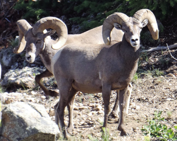
The South Rim Road follows the canyon with 13 pullouts along the way. From your vehicle, you can get a more or less adequate view of the canyon. Take just a short walk out to the very lip of the canyon from any or all of the pullouts and the views are way better than just adequate. At the Sunset View pullout, for example, you can look down a long stretch of the canyon to where the sun seems to decline into the notch formed by the walls. It is a lovely place to visit right after your supper when the sky turns all golden and red and deep purple velvet. Sunset View is where Shirley and I met about a dozen bighorn sheep. The ewes and lambs moved away promptly, but a couple rams hung around to give us a good look-over and serve as a rear guard.
The campground is a safe haven for quite a few deer, especially newborn fawns and their mothers, because predators are less likely to intrude there. A mule deer doe sought relief from the July sun by plopping down in the shade right next to our RV, and her twin fawns meandered through regularly even as we sat reading or sipping adult beverages in our camp chairs. Similarly, a grouse hen came to feed on the serviceberries at our campsite. She was not at all shy in our presence.
After sunset, the dark, sacred night becomes the attraction. Because of its distance from major metropolitan areas, the night sky at the Canyon is unaffected by so-called light pollution. One moonless night, members of the Black Canyon Astronomical Society brought huge telescopes and invited campers to have a look. By “huge” I mean we had to climb six-foot step ladders to reach the eye pieces. Rings of Saturn, oh, my! And what looks like a bright star at a corner of the Big Dipper is actually a binary, two stars orbiting each other. Even without the telescopes, the night sky is still simply amazing.
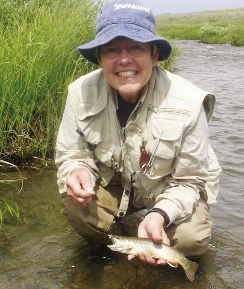
There are trails along the rim of the canyon and out to Warner Point that are relatively easy. There are also trails for the young, strong, and very courageous that make the precipitous descent all the way to the river. Many who do this are motivated by the trophy trout that reside in the rushing waters down there. Now, Shirley and I have used the park several times as a base for fly fishing in the area, but we have never been so highly motivated that we would go all the way down there and then deal with the near-vertical climb back up.
We think there is a much better way to get into the canyon. The Park Service offers a ranger-narrated boat tour on the Gunnison River that begins at Morrow Point. Reaching the 42-passenger pontoon boat requires a drive back down to Rt. 50 and then east about 25 miles. There is no point in making that drive unless you first call ahead for the required reservations. And there is no point in that either if you have physical limitations. The Park Service is very explicit about the effort required to reach the boat dock: first you descend exactly 232 steps (which, obviously, you will climb coming out) to a trail on an abandoned narrow-gauge railway bed that follows the river for a scenic three-quarter-mile stroll. “We suggest leaving the trailhead no less than 45 minutes prior to the tour and allowing more time for a slower pace,” says the Park Service. After descending from the canyon rim, you are still at about 6,500 ft. elevation and, if not yet acclimated, you may find yourself a little short of breath and walking slower than usual. If you are not confident that you can descend 232 steps and walk three-quarters of a mile at the brisk rate of 1 mph, perhaps you should rethink the whole thing.
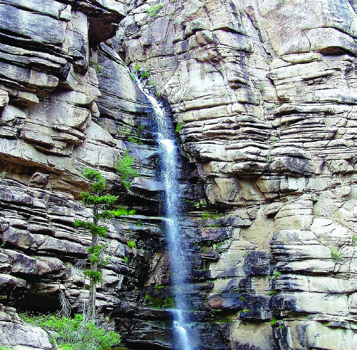
If you decide to go, be prepared for more park humor. On the dock, we were required to don life jackets and have the security of the buckles pass ranger inspection. When actually aboard, however, we were permitted to remove the vests and stow them under our seats. If you are inclined to scoff, bear in mind that safety should be taken seriously. So, do your scoffing in the silence of your head. The rangers are all too aware that they are sometimes required to follow ludicrous procedures established by bureaucrats who have never been within 1,000 miles of the park. Smart-alecky passengers don’t make things any easier for them. Besides, by the time you complete your tour, you will probably have forgotten all about that anyway. The boat cruises past landmarks such as the granite Curecanti Needle, rising 700 feet at a bend in the river, and Chipeta Falls that spills from way up the cliff face. There is also the chance to see falcons, ospreys, and swifts, and hear a canyon wren sing “Down, down, down, down!” Watch for bighorn sheep on the sheer cliff walls, too.
Now, I suggested that the Black Canyon could be reached via the scenic route up from Durango. Actually, that is just one of the scenic routes. Shirley and I have also enjoyed the drive west on Rt. 50 from I-25 and to the North Rim on Rt. 133 from I-70. There is a campground on the North Rim that is somewhat quieter and less visited if you prefer that sort of thing. Bear in mind, though, that there is no visitor center on the North Rim. If you like national park exhibits, T-shirts and souvenirs, and advice from rangers, this may not be your best choice. Also note that there is no direct route from one rim to the other, so you will need to allow two or three hours should you decide to make the drive to the other side of the canyon. We have never done that.
If you pick up a Colorado map, you will notice that the roads in the western two thirds of the state tend to have little black dots all along them because they are designated scenic routes. Well, yes, of course they are! All of the ways to reach the Black Canyon are scenic. There is simply no bad way to get there. Even I-70, not particularly awe-inspiring between Ohio and Denver, suddenly becomes a joy to drive, especially through the Glenwood Canyon section that parallels the Colorado River with white-water rafters rushing through it. In our opinion, once you reach the Front Range of the Rocky Mountains, you just can’t go wrong.
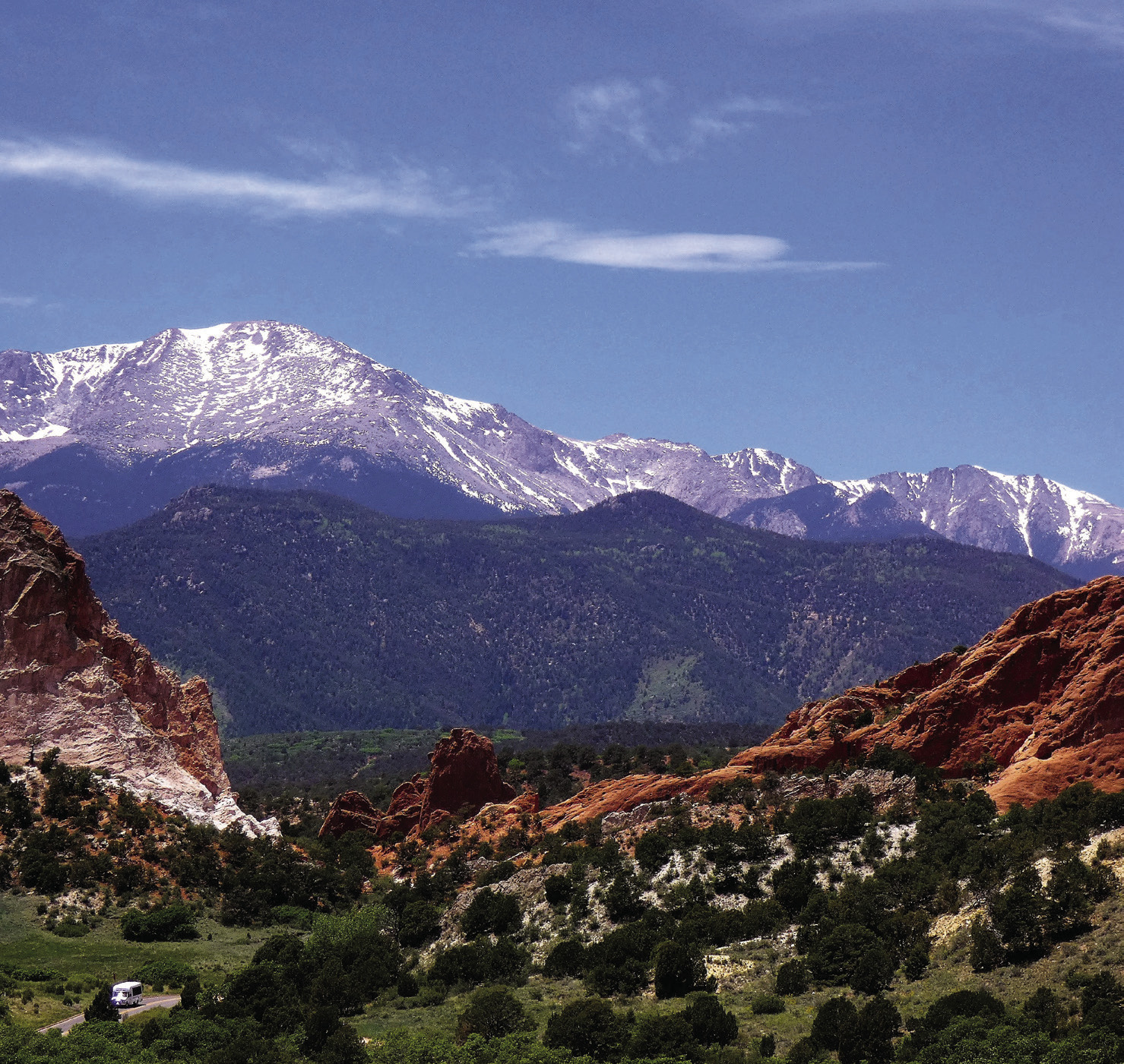
None of this matters, though, if you are totally unimpressed by purple mountain majesties, above the fruited plain. (That would be Pike’s Peak near Colorado Springs that inspired the song.) But being unimpressed is not entirely beyond possibility. Shirley’s father, bless his heart, was a flatland farmer apt to make observations such as “Ya seen one mountain, ya seen ‘em all” or “Mountains just get in the way of the view.” Which is why I am tempted to think that infant Shirley was secretly left by the fairies. She has a soul built for outdoor adventure. And a good thing it is too or she would have missed out on many a delightful walk in the park.
You might want to see more of his stories and photos at AnotherWalkinthePark.blogspot.com. ✲