
-
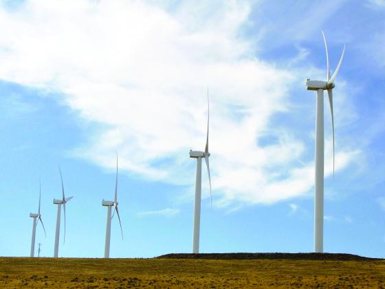 Wind farms along the top of the bluffs take advantage of the way prevailing westerlies are compressed and funneled up the Gorge.
 -
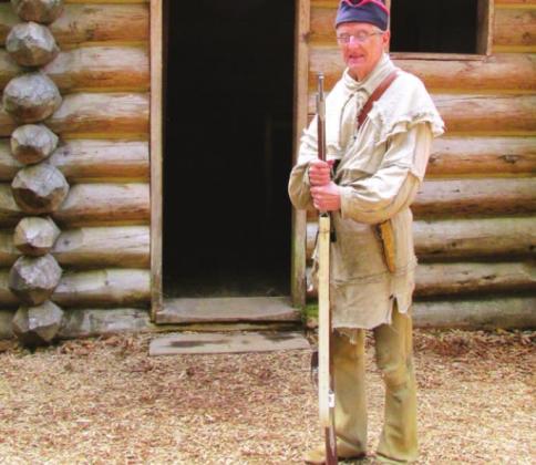 This volunteer described what life was like at Fort Clatsop and demonstrated the art of loading and firing a muzzleloader. When we returned seven years later, he was still at it.
 -
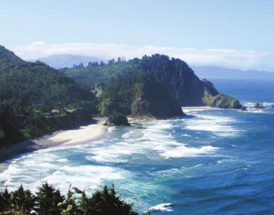 If you follow the Columbia all the way to the Pacific, you may be inclined to echo William Clark:” Ocean in view! O! the joy!”
 -
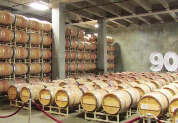 Columbia Crest has an unbelievable 21 acres of cellars in which to age their wine. The “90” on the wall is their way of bragging that they have more wines rated 90 or above than anyone else.
 -
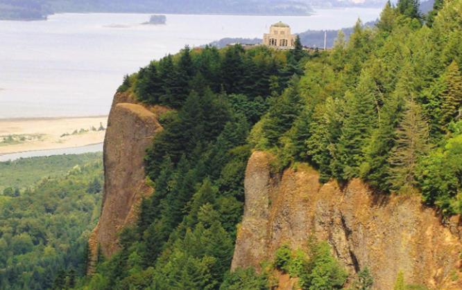 Vista House sits on Crown Point with amazing views up and down the Columbia River Gorge.
 -
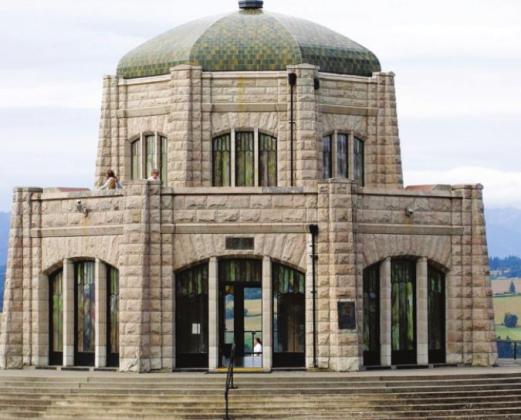 Though technically just a rest stop on the Historic Highway, Vista House serves as a memorial to the pioneers who settled Oregon.
 -
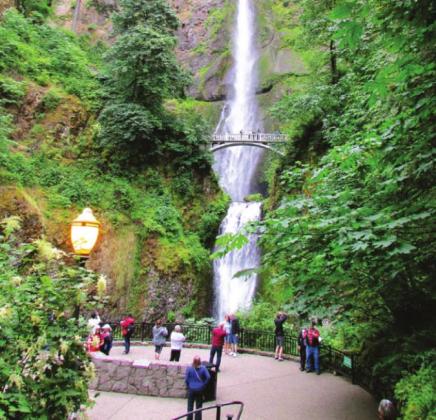 Multnomah Falls is the most visited natural attraction in Oregon.
 -
 This Bridal Veil is one of the prettier of the 2,173 by the name in the U.S. Landmarks are often named by people who are inclined to rely on cliches. But a rose by any other name....
 -
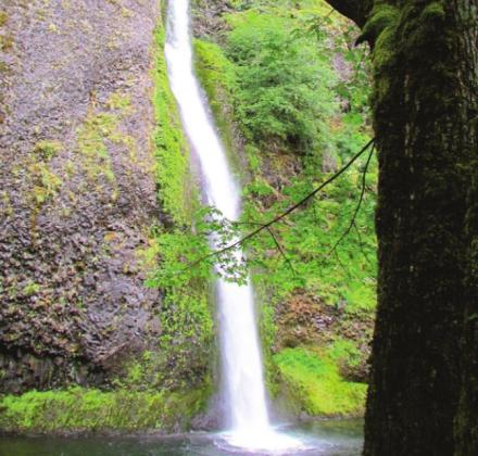 Horsetail Falls is a big favorite of those averse to hiking because it is just a few feet from the highway.
 -
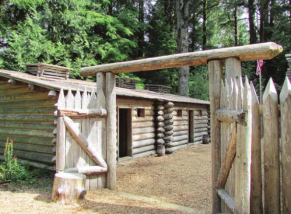 Fort Clatsop was rebuilt in 2005 for the bicentennial of the Lewis and Clark Corps of Discovery. The drawings and journal of William Clark were used to make it as authentic as possible.
THE MIGHTY COLUMBIA RIVER is born high in the mountains of British Columbia and flows south until it makes a sharp turn west to form the boundary between Oregon and Washington. For centuries it was a major Indian route from the Rockies to the Pacific. Lewis and Clark were the first white men to travel its lower reaches. At the mouth of the river they built Fort Clatsop to spend the winter of 1805-06 replenishing their food supply and making salt for the return east when spring would make it possible to cross the Rockies. Within a few years the area was a destination for fur trappers and then settlers on their way to the fertile valleys and mild climate of Oregon. John Jacob Astor’s Pacific Fur Company, for example, was also at the mouth of the Columbia in the little town of Astoria.
Traveling down the Columbia is much easier these days. Interstate-84 passes through the Gorge, mostly at river level. You could take that route if you were in a hurry to reach Portland. Shirley and I reach the Columbia River by heading north from Yellowstone and, following the Lewis and Clark route, up to the Lolo Pass on the Montana-Idaho border. This is where the explorers hoped the mountain challenges were behind them. Uh, oh! Maybe not. From Lolo Pass there is nothing ahead but a seemingly endless series of ridges marching all the way to the misty horizon.
We fish the Lochsa River and hike portions of the actual Lewis and Clark trail that runs along the ridge above the water. Near the place where the Snake River emerges from Hell’s Canyon are the twin towns of Lewiston, Idaho and Clarkston, Washington. Eastern Washington is mostly high, steeply rolling hills of golden wheat in the summer. Classic purple mountain, amber waves of grain country.
Our first stop on the Columbia is at Plymouth, WA where there is an exceptionally nice Corps of Engineers campground on a bluff above the river with a canopy of huge cottonwood trees for shade. We use it as a base for visiting the wineries in Washington just up river from there: Chateau Ste. Michelle, Columbia Crest, 14 Hands, and our old family favorite, Mercer. Tours and tastings have always been pleasant because the wines are excellent values and the staff at each is friendly, generous with their pours, and patient with visitors.
Mostly patient, anyway. We stopped to visit my “cousin” Liz Mercer Elliot at the winery that, by the way, has been named Washington Winery of the Year. She gave us a private tour but declined a “family discount” on a case. “Do you have any idea how many people named Mercer stop here expecting special treatment?” she asked rhetorically. “Oh, we would never impose on the connection,” I said. (Mainly because there is no connection.)
After a few days at Plymouth, we cross the river back into Oregon to take the 75-mile Historic Columbia River Highway that runs high on the cliff face. There are multiple attractions—dramatic scenery up and down the river, Bonneville Dam, Vista House at Crown Point, and Beacon Rock, an 848-foot monolith rising at water’s edge. There is also a world of wine on the Oregon side of the river. Or so we have heard.
The Historic Highway is narrow with numerous sharp turns and steep ascents. It is not appropriate for large RVs or drivers who get nervous at the thought of sheer drop-offs. Before the 1846 construction of the Barlow Road, that detoured over to the base of Mt. Hood, travelers on the Oregon Trail built rafts to float downstream. This was even more daunting back then than it would appear today. Before Bonneville Dam backed up and deepened the water, there were dangerous rapids and cascades along this stretch of the river. Emigrants created portages, canals, and locks to bypass the obstacles.
Vista House at Crown Point, on a 600-foot bluff, is an impressive stone edifice dedicated to the memory of these intrepid pioneers. It provides a rest stop and a prime vantage point, particularly on its upper deck, from which to enjoy the view. The location is astounding, and so were the construction challenges. Engineers designed and built a figure-eight road that doubles back on itself as it climbs the bluff.
Today, the natural aspects of the Gorge are features and benefits rather than obstacles. From Vista House you can see the steady flow of traffic on I-84, trains running on tracks just a few feet from the river, ships and barges, sternwheeler sight-seeing boats, fishing boats, and other pleasure craft. The prevailing west wind is funneled through the Gorge providing an attractive opportunity for windsurfing, kiteboarding, and sailing. Also for an extensive array of windmills on the top of the bluff. The area is appropriately called Viento, Spanish for “windy.” Those of you who are especially adept at trivia may know that it is not Spanish but actually based on the names of three railroad men who developed the area—Villiard, Endicott, and Tolman.
On the Oregon side of the river, the cliffs are adorned by more than 90 waterfalls. Most are difficult to reach or totally inaccessible, but several particularly impressive ones are lined up in a nine-mile stretch along the Historic Highway. All are within short walks of parking areas that, by the way, can’t accommodate all the traffic, so start your day early. Portland is only 30 miles from the west end of the Gorge, so visitors are particularly numerous on weekends. Or you might hop on the Sasquatch Shuttle and avoid the hassles with traffic and parking. The fare of $15 is good for one day, and you can get off and back on at any of the stops.
The most spectacular of the stops is at Multnomah Falls—the most-visited natural tourist attraction in Oregon. In the 1880s, steamboats and excursion trains started to bring visitors to marvel at the 620-foot ribbon of water. The Forest Service says Multnomah is “the second tallest year-round waterfall in the US.” (First would be Oloupena on Molokai at 2,953 ft.) For comparison, Niagara is 167 feet and Yosemite is a whopping 2,425 feet but is disqualified because it runs dry in late summer. Multnomah Falls is divided into a 452- foot upper section and 69-foot lower section. Those of you who passed 3rd grade arithmetic may have noticed that this does not add up to an official height of 620 feet. But there is a more gradual nine-foot drop connecting the two sections. A short, steep trail begins behind the lodge and climbs to the picturesque Benson Footbridge between the two sections of the falls. You need sharp elbows to secure a place to stand for your photos. Or depend on the kindness of strangers. A bigger challenge is to find a vantage point from which you can get the whole 620 feet in your picture.
On our first visit, Shirley and I stayed at the nearby Eagle Creek Campground because it was a convenient base for visiting all of the falls. Built in 1916 as the very first Forest Service campground in the country, it was upgraded in the 1930s by the CCC with “impressive modern conveniences” such as flush toilets. Today, as then, the most impressive aspect is the natural setting among the ancient Douglas firs. There are also three Oregon state parks in this short stretch of the Historic Highway—Rooster Rock, Benson Lake, and Ainsworth. Oregonians love their state parks and, though there is a total of 255, they seem to be fully booked most of the time.
Just a half mile from Multnomah is Wahkeena Falls. All the falls parking areas fill up early, so many visitors find it easier just to walk the half mile up the road rather than spend their time waiting for a space to open up. For those even more ambitious, there is a scenic five-mile loop trail that gains 1,600 feet as it connects the two. For ordinary mortals, there is a 900-foot paved pathway leading to a stone bridge that stands within the mist of the falls. Wahkeena, at 242 feet, is shorter than Multnomah, but it has charms of its own and appeals to wedding parties.
Speaking of which, Bridal Veil, one of the prettiest of that name in the U.S., is 118 feet high and reached by a half-mile walk down the slope that can be done in about 15 minutes. Maybe a little longer if the bride is concerned about her gown. Coming back up might take a little longer, but the experience is worth the modest effort. There is a wooden platform below the plunge pool to make composing your photos somewhat easier.
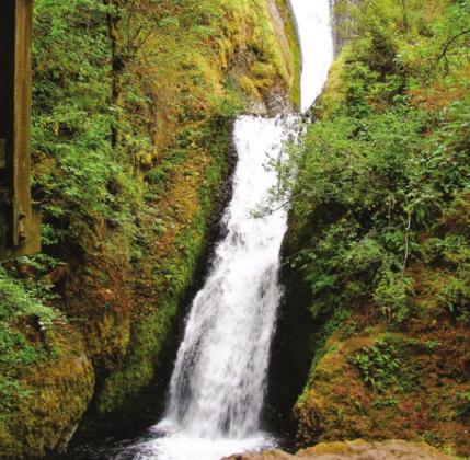
Horsetail Falls requires no hike whatsoever because it is right next to the road. Even so, there are always those who insist on bushwhacking their way up the cliff and ignoring the signs that warn against slippery, moss-covered basalt rocks that might produce unpleasant consequences. Horsetail drops 176 feet and is 15 feet in width. It is described as “magical” in tourist literature and deservedly so. Millions of visitors have decided it is worth driving in circles through the parking lot until a space opens up because that effort is also justified. (At $15 each on the Sasquatch, a car load could cost $60-$75.)
Latourell Falls is reached by an easy quarter-mile walk, or you might choose the two-mile hike to the upper falls. It is a beautiful walk, but how easy it is depends on your age and fitness level. The trail is a good way to avoid the crowds. Latourell is 224 feet in a straight drop and is easy to identify and remember because of the bright chartreus lichens growing in the mist on the rock face to the right.
On that first trip, we turned north at Portland and headed past the remains of Mt. St. Helens to Mt. Rainier National Park, then over to Olympic National Park in the northwest corner of Washington, then down the coast to the mouth of the Columbia and Lewis and Clark’s Fort Clatsop.
On our second trip, we went south instead in order to visit Mt. Hood. Stayed at Nottingham Campground within a few feet of the East Fork Hood River in the national forest. From there, we followed the Columbia to Fort Clatsop before heading along the coast to Redwoods National Park in Northern California. The scenery in the great Pacific Northwest is simply stunning. If you are into things like hiking, bicycling, fly fishing, history, photography, fresh seafood, wineries, rugged sea coasts with lighthouses, wildlife, and a thousand other active or relaxing activities, you just can’t go wrong. There is an unbelievable variety of natural beauty and numerous cultural attractions, and it is so accessible that you’ll find the whole experience just a walk in the park.
LeMoyne Mercer is the travel editor for Healthy Living News. If you are contemplating a trip, you might want to see photos and information about numerous destinations at AnotherWalkInThePark.blogspot.com.